About Berriedale
On the most North-Eastern part of the North Coast 500 Scenic Route, Berriedale is a small fishing village on the East coast of Caithness and is the most Southern village in the county before crossing into Sutherland.
The village is packed with fascinating sites and has a rich history that can be traced across the landscape in almost every footstep. In the tranquil harbour there are remnants of an old salmon fishing station from the 1840’s, now rejuvenated, and looking to the craggy hillside above, you can find the twin towers that used to be lit to guide the boats in the darkness. The remains of Berriedale Castle, at the peak of its power in the 16th Century but today stands in ghostly ruins, can be seen on the spit of rock jutting out from the shoreline.
The beautiful church half way up the brae heading North was designed by Thomas Telford, as was the original stone bridge that crosses Berriedale Water at the foot of the valley near the main village street. Here you’ll find where the Berriedale and Langwell Waters, which carved out the dramatic landscape of the braes, meet on their journey to the sea. Only a few miles South of Berriedale, you can explore one of the best preserved iron age broch sites in Caithness at Ousdale, or take a walk through the unsettling ruins of Badbea, a long abandoned Clearance settlement.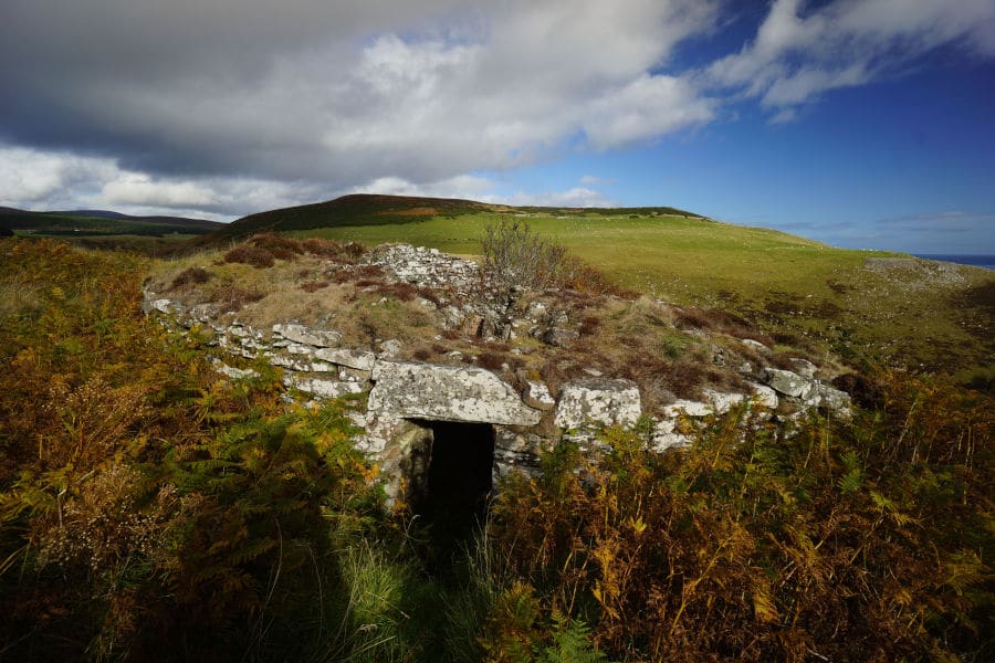


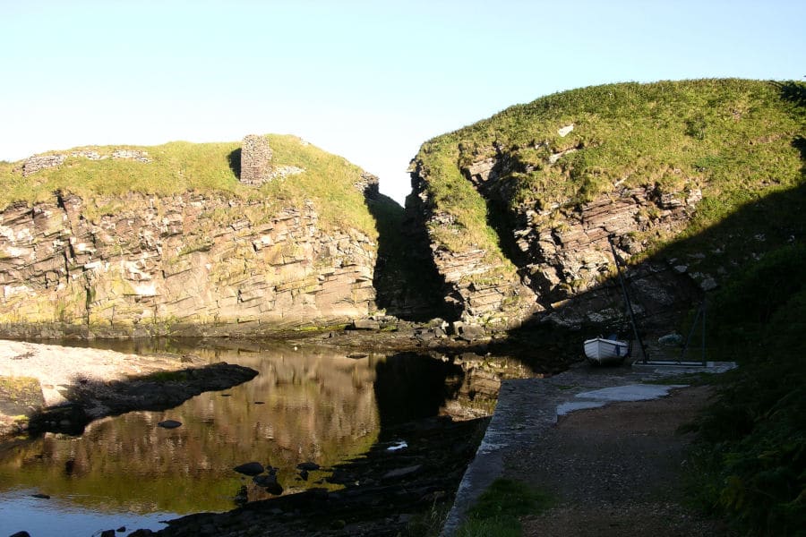
Berriedale Harbour
The narrow entrance to the harbour leads to a small quay, now only used by the occasional fishing boat. Overlooking the bay, the shingle beach is sheltered by craggy cliffs and the perfect spot to look out for sea birds and resident seals. High on the hillside above, you will notice two crenellated towers called the Duke’s Candlesticks after the Duke of Portland. Thought to date back to the early 19th century, the towers were navigation beacons used to guide in the fishing boats.
Taking the footbridge across Berriedale water, you come across a terrace of buildings, the remains of an abandoned salmon fishing station. Now known as The Shore Cottages, the four fisherman’s cottages, ice-house, storeroom and bothy date back to around 1840. Derelict for 60 years, the cottages were renovated by the Landmark Trust in 2011 and are now available as holiday lets.
From a time poignantly captured in Neil M Gunn’s novel ‘The Silver Darlings’, the history of The Shore goes back even further, to the late 18th century, when the area was settled as part of the Highland Clearances and many evicted crofters found a new livelihood in the booming herring industry. By 1840, more lucrative salmon fishing was the mainstay in Berriedale, as larger herring stations were already established in nearby villages along the coast.
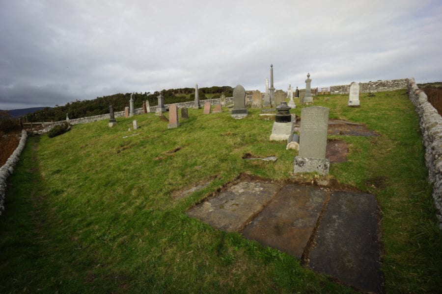
Berriedale Castle
Little remains of Berriedale Castle today, but it would have been an imposing site at the height of its power in the 16th Century. Perched on a spit of rock across the Berriedale Water, the castle had a strategically defensive position with a difficult approach from the landward side, and the North sea on the other. The best view of the site is from the graveyard at Berriedale as you head North up the brae.
Although there may have been earlier fortifications at the site, the Castle first appears in records in 1330 – 1331 when Earl Malise of Caithness, Orkney and Strathearn installed here Reginald More, Great Chancellor of Scotland. In 1345, the Castle was granted to Reginald Cheyne, and upon his death, it passed through marriage to the Sutherlands.
The Sutherlands retained the castle until the late 1400’s, when it then passed to the Oliphants. In the following years, the Oliphants held the castle against frequent attacks from the Sinclairs and other local families. However, in 1606, the Oliphants relented and the castle and its lands were resigned to the Earl of Caithness. The Sinclairs inhabited the castle until 1676, at which time it was seized by John Campbell of Glenorchy following the passing of the last Earl of Caithness, who died without an heir. What happened to castle after that is unclear but the site had been abandoned by the middle of the 18th Century and left to ruin.
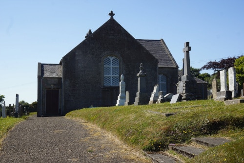

Berriedale Church & Cemetery
Berriedale Church was closed by the Church of Scotland in 2008 and was at risk of being sold off into private ownership. Thanks to the generosity of the nearby Welbeck Estate, the Church and graveyard were purchased to preserve this beautiful building and its history, and for the benefit of the community. The Berriedale Church and Cemetery Association was formed to administer the building and grounds.
There is evidence of a church at Berriedale (or Baridal or Bardual as it was written then) from old maps dating as far back as 530AD. In 1066, the first Catholic chapels were erected in the area, following the appointment of Bishop Darrus as Bishop of Caithness.
Parliament later commissioned Thomas Telford to undertake the construction of many churches and manses in the Highlands, and following the granting of land by James Horne, the owner of Welbeck Estate at the time, the current Church with its distinctive bell tower and manse was completed in 1826 by William Davidson at a price of £1473. In 1833, Berriedale was raised to the status of a Quod Sacra Parish.
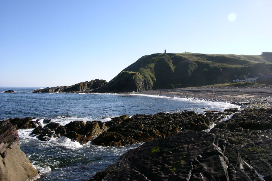
Badbea Clearance Village
High on the clifftops, some 2 miles South of Berriedale lies the abandoned clearance village of Badbea. The Berriedale straths were cleared of crofters in the 1790s by Sir John Sinclair of Ulbster, who purchased the Langwell Estate in 1788, and evicted small holders to introduce more profitable sheep farming onto the land. At that time, some 12 families were relocated to Badbea. In 1804, more households were evicted by James Anderson, who had let the farm land at Ausdale. Another wave of evictions, this time from Auchencraig, by James Horne who had bought the Langwell Estate in 1814, further swelled the Badbea population.
It was a bleak existence in such an unforgiving and inhospitable landscape. Livestock and even children had to be tethered to stop them being blown over the cliffs in fierce winds. Houses were hastily made from the stone and materials nearby. Most of the men were employed as fishermen at the shore in Berriedale, while the women would work to gut and store the catch on their return.
From the 1850’s, the population of Badbea gradually declined, its residents leaving in search of a better life. The last resident left in 1911, and the village was left to return to the elements and the stone houses fell into ruin. There is a statue on the site, erected by Donald Sutherland, the grandson of a Badbea resident, in memory of the resilience of the people of Badbea and the Clearances.
Ousdale Burn Broch
Whilst Caithness is peppered with Iron Age Broch sites, the site at Ousdale is one of the best preserved of these enigmatic iron age structures in the county. The broch has an external diameter of about 50ft, with walls 14ft high. The narrow entrance passage contains two sets of door-checks, and there is a guard-cell to the side in which a square cist containing a cremation was found.
Initially excavated by James Mackay in 1891, finds from the site have included pottery, animal bones, and stone artefacts such as a granite mortar, whetstones and querns, among others. Mackay also found a human skeleton under the narrow opening over the entrance to the stairs.
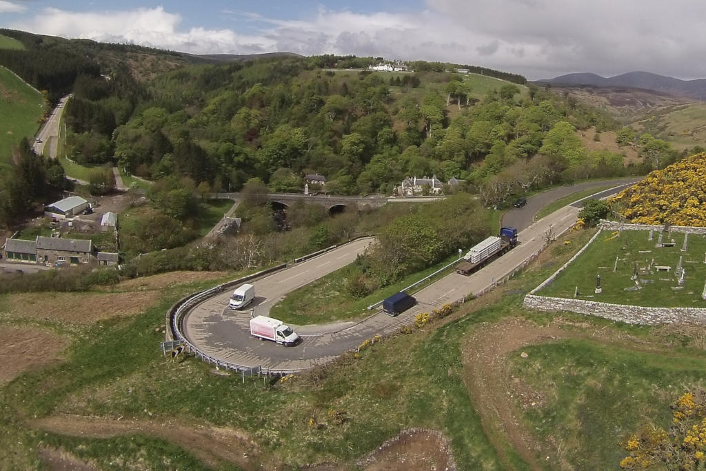
Berriedale Braes
As with Dunbeath’s Tale of Two Bridges, a description of Berriedale would be incomplete without mention of the notorious Berriedale Braes.
The steep decline to the bottom of the valley floor is only matched by the even steeper climb up to the other side, heading North. The route offers fantastic views but is not for the faint hearted driver. The hairpin bends make this one of the windiest and challenging sections of the main A9, with oncoming traffic in the middle of the road and large vehicles struggling up the hill.
Despite improvements, the essence of the braes remain. However, the slowing traffic is the perfect excuse to take a break and explore beautiful Berriedale. Just take care not to mistake the sandy escape lane for vehicles with failing breaks as a convenient parking spot.